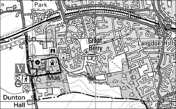
Start Point: Langdon Visitor Centre, Third Avenue, Lower Dunton Road, Basildon.
Essex Wildlife Trust: 01268 419103
Ordnance Survey: ref: TQ 661 874
Distance: approx 1.6km (1 mile)
Time: approx 1 hour
Walk Conditions:
Bridleways and footpaths, all off road. Muddy at times. Natural aspect includes hills. Paths are unlikely to be suitable for pushchairs or wheelchairs.
![]() From the Visitor Centre turn right and head up the surfaced track in front of you.
From the Visitor Centre turn right and head up the surfaced track in front of you.
On your left, slightly off the main track, are the remains of Protem and Edoran, two slate roofed, timber-framed bungalows.
The rubble now makes good habitat for reptiles including slowworms and adders. Nearby is a map showing the layout of the avenues and their plots.
Continue eastwards along the main track. This track is Third Avenue. Previously all the avenues were grassy tracks, muddy and often impassable in winter. The community worked together contributing time, money or materials to create a network of concreted footpaths following the avenues.
Approximately 200 yards on your left is The Haven Plotland Museum. Built by the Mills family in the mid 1930's, it was their home for forty years. The house is opened to the public by a team of volunteers. Please contact the Visitor Centre for details.
Continue eastwards up Third Avenue. Tucked in the undergrowth marked with a Plotlands Trail marker number 4, is a set of concrete steps. These led to the veranda of Trees, home to Mrs Burningham & family. To the rear of the plot you can see the layout of garden including a horse chestnut tree planted by the family.
![]() Return to Third Avenue and continue to the top of the hill. Turn left at the crossroads and enter a plotland garden via a gap in the hedge on your left. Plotlands Trail marker 5.
Return to Third Avenue and continue to the top of the hill. Turn left at the crossroads and enter a plotland garden via a gap in the hedge on your left. Plotlands Trail marker 5.
The curved brick wall ahead of you marks the bay window once part of 'Hawthorn' home of Burke family from Barking between 1932 and 1983.
The 110 x 209 ft plot is marked in the corners by a Monterey cypress, an oak and a willow. Return to the grassy track and turn left along Hillcrest Avenue.
As you walk along note that the ground rises and falls every 4-5yards. These are stech marks, remains of the ridge and furrow patterns created by horse drawn ploughs during the pre-plotlands agricultural era. This land was known locally as 'Three horse land' because its heavy clay soil required three horses to pull the plough. The soil and the steepness of the hill were the main contributing factors to the sale of land in the 1920's.
![]() Continue northwards along Hillcrest Avnet, passing the remains of 'Iona' in the undergrowth (Plotlands Trail marker 7). At the crossroads look west.
Continue northwards along Hillcrest Avnet, passing the remains of 'Iona' in the undergrowth (Plotlands Trail marker 7). At the crossroads look west.
This point offers stunning views across to the skyline of London, including Canary Wharf and the QEII bridge over the Thames at the Dartford Crossing.
You are standing on the edge of the Langdon Hills looking west over the Tilbury Plain. Before the Ice Age the Thames used to flow to the north of the Langdon Hills (to your right) until the ice sheet, which came as far south as mid Essex, dammed this route and forced the river to flow on its present course to the south of Langdon Hills (to your left).
The Southend to London railway line, the main route for most of the Plotlanders, can clearly be seen to the right. During the Second World War this was a safe vantage point from which to observe the dog fights of the Battle of Britain. The three fir trees ahead mark site of Everest, a café and small grocery shop.
At a crossroads continue straight on and take the next path on your left. Plotland Trail marker 10. You are entering St Andrews, one of the largest properties on the estate
As the path emerges from the over hanging branches look back to catch the spectacular sight of the Virginia creeper which has engulfed the trees and old walls. This is especially dramatic in late summer when the leaves turn flame red.
![]() Follow the path through St Andrews and onto Second Avenue. Turn left and take the first path on your right, following the concrete path in the grass. Plotland Trail marker 11.
Follow the path through St Andrews and onto Second Avenue. Turn left and take the first path on your right, following the concrete path in the grass. Plotland Trail marker 11.
The concrete base on your left marks the tiny timber dwelling called Juliase. As with many plots the garden was well planted with fruit trees, including apples and pears.
Most plotlanders were to some degree self-sufficient growing fruit and vegetables, keeping livestock such as geese and chickens or beehives for honey.
![]() Follow the path down to the bottom right hand corner of the garden, through a wooden squeeze, turning right when you reach an open grassy area.
Follow the path down to the bottom right hand corner of the garden, through a wooden squeeze, turning right when you reach an open grassy area.
Ahead of you is a wooden fence surrounding a hole in the ground. Plotland Trail marker 12. These bottle wells were dug by out of work gravediggers and collected rainwater via land drains. By 1937 mains water was laid along the avenues with standpipes at the top or bottom of each, although many plotlanders continued to rely on collected rainwater. Some of the bottle wells now house the rare cave spider.
Follow the path round the remains of Edoran and Protem to return to the Visitor Centre.