|  | The 103 mile Two Moors Way footpath - the oldest regional footpath in Devon - starts at Ivybridge, runs across Dartmoor and mid-Devon and, crossing some of the wildest parts of Exmoor, finishes its journey at Lynmouth.
In the past quarter of a century the Two Moors Way has attracted thousands of walkers from all over the world. The idea of a long-distance route across Devon dates back to the 1960s. Originally there was much opposition from landowners and a path using existing rights of way was created instead of a totally new route. 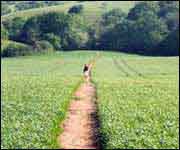 | | The route crosses farming countryside |
A "packhorse" service has now been established, transporting walker's packs between their nightly stops. The information centres at Ivybridge and Lynmouth provide logging-in facilities for travellers.
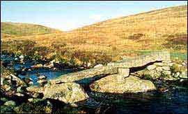
The Dartmoor section of the route winds across the wilderness of southern Dartmoor, from Ivybridge to Holne, before following the spectacular and beautiful Dr Blackall's Drive and the great ridgeback of Hameldon. Following footpaths to Chagford Bridge it leaves Dartmoor at Drewsteignton.
The mid-Devon section is gentler and pastoral, using ancient footpaths and bridleways linking settlements such as Morchard Bishop, Black Dog and Witheridge.
The path enters the Exmoor National Park at Anstey Common and winds through beautiful river scenery and lonely moorland before making a spectacular descent into Lynmouth via Myrtleberry Hangings.
While the ability to use a map and compass is necessary on the moorland stretches, the Two Moors Way is recognised as a good first step for ramblers who have never walked a long-distance path before. The variety of scenery, pretty villages, ancient monuments and old churches provides a wonderful introduction to the heart of Devon, both for visitors and local walkers.
The Two Moors Way can be walked in a week by any reasonably fit person, or explored in a series of day walks. Spending longer on the route would give an opportunity to really explore the lovely countryside and historic villages along the way.
An official guide has been published by the Two Moors Way Association. This details the entire route at an approximate scale of 1:18,000 with accompanying instructions where clarification is required. 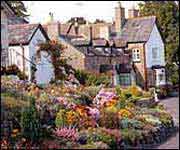 | | Holne village on the edge of Dartmoor |
This book is available in local shops and Tourist Information Centres, or may be purchased from the Two Moors Way Association, 63 Higher Combe Drive, Teignmouth, TQ14 9ML, price £4.95 including p&p.
The Two Moors Way Association also maintains an updated list of accommodation on or near the route. Details of a packhorse service for luggage carrying are also available. A copy of the most recent list may be obtained from the above address, price 50p plus a stamped addressed A5 envelope.
Relevant OS maps
For an overview of the route, the Ordnance Survey's 1": 1 mile scale Touring Maps covering Dartmoor (Touring Map 1) and Exmoor (Touring Map 5) between them cover the whole of the Way.
The route is covered at a scale of 1:25,000 by the following maps:
Outdoor Leisure no. 28
Dartmoor Explorer no. 113
Okehampton Explorer no. 114
Exeter and the Exe Valley Explorer no. 127
South Molton and Chulmleigh (1 km only)
Outdoor Leisure no. 9 Exmoor. |