24 September 2014 |

| |
BBC Homepage | |||
Contact Us | |||
History WalksYou are in: Derby > History > History Walks > Findern History Walk 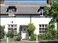 The Old Post Office, Findern Findern History WalkTake a stroll through this pretty South Derbyshire village, mentioned in the Domesday Book, and uncover its history. Look out for a Saxon place of worship, the grave of a racing driver and the home of a former MP!
Standing with your back to the church wall at the car park - you are looking at the old centre of Findern which used to be known locally as Bumpton. There was a row of cottages where you are now standing and, to your right, there was a farm where Brook Close has been built. The old village school (which was demolished in 1935) was at the entrance to Brook Close and had formerly been a Unitarian Chapel. The flower bed in front of you was an outbuilding, belonging to the shop which was in the cottage behind. The modern cottages you see today were rebuilt where the others were demolished. There were two other cottages to the right of the flower bed, demolished around 1930. Although the cottages were close together and many had large families living in them, they all helped each other out, and doors were never locked so neighbours could pop in. Water came from the well in front of the chapel and most cottages had a fenced garden on the common land on Common Piece Lane. 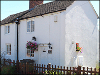 Ivy Cottage From the car park, walk straight down Common Piece Lane. Notice the Old Hall on your left behind large wooden gates, where the Wollatt family lived (Jedediah Strutt married their daughter, Elizabeth, in 1755). Continue to the Methodist Chapel, built in 1835 (at a cost of £100!) and the well at the front. This was renovated by the Brownies, along with the garden in 1984 and won a national competition. Walk on down Common Piece Lane to look at Ivy Cottage on your right. This is one of the oldest dwellings in the village, parts of it dating from the 17th Century and was once a weaver's cottage. 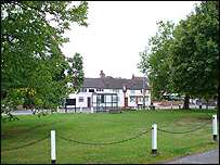 The Village Green If you wish, continue walking down Common Piece Lane in front of the cemetery, past what are now allotments. Cross the brook, and in the field on your left, you can see raised banks which are the remains of the banks of the Abbott's fish-ponds. Retrace your steps to the car park and follow church wall towards the Green. You will pass the Parish Rooms, originally two cottages, and bought as a village asset in 1895. They were altered to make two connecting rooms, without an upstairs, and used for social events and parish council meetings. Findern Church and the Green. The present All Saints' Church was consecrated in 1863 on the site of a Saxon place of worship. It cost £2,000 and contains some items from the old church, the two bells, the 1662 font and the tympanum of the Norman doorway. 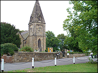 All Saints' Church Follow the church wall and find a plaque commemorating the WI's Jubilee in 1966 when members helped to pay for the chains and posts around the Green. In the 1900s, there had been a pond in front of the church and paths criss-crossed the Green but were later covered in tarmac. The Parish council bought the land as an amenity for the village in the 1950s and the area was cleared and re-seeded and has been an attractive place ever since. Walk from the church wall to the long white building, Number 19 The Green. This was used as the Post Office until the 1950s. Turn the corner to your right into the cul-de-sac. The cottage on your right at the far end is Poplar Cottage, Number 15, which has a modern extension in the front but the rear is unchanged. It was a private school run by Miss Manifold, whose grave is in the churchyard opposite the Parish Rooms – she died in 1900. 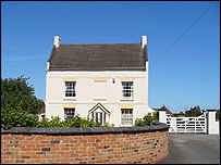 Corner House Look towards the large square house in the corner. Corner House, an early 18th-century farmhouse, has a central window bricked up to avoid the window tax enforced until 1851. An old Findern family has lived here for generations. Walk back towards The Green, past the new houses to Glebe House. This property originally belonged to the church and the schoolteacher lived here in the 1900s. He kept the children in order, both in and out of school. The Old Forge next door used to be a farm, and where the nursery car park is now, stood the blacksmith's shop.  The former blacksmiths forge With the Green on your left cross the road (take care) and turn right to walk down the hill. On your right is Number 7, The Green - originally Hillside Farm - part of the Harpur-Crewe estate, and a working farm until 1952. The kitchen and bedroom above are 17th-century; the other parts have been added over the years. Continue down Doles Lane to Archway Motors, built around the site of Yew Tree Farm which had a large arched entrance. The farmhouse is now 14 Doles Lane, and is the large white building below the showroom entrance. Next door is Willow Farm, an elegant 19th-century building which was a working farm until 1990. Cross the bottom of Cromwell Ave and walk on until you are opposite the end of Bakeacre Lane. The property on the left side was East Farm, sold and altered mid 1970s. 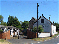 Spring Farm On the right is Spring Farm which originally had a cottage next door with a separate entrance on to Doles Lane, but this has been incorporated into the present building. The farm's name comes from the fact that water was supplied by a spring. The well can be seen in the yard, now converted to a flower bed. If you wish to get a look at Wallfields House, walk along the 'high pavement' to the entrance (it is now a residential home). It was built in 1822, with an adjoining farm and workers' cottage at the far end of Doles Lane. In 1957 Reg Parnell, the famous racing driver retired here, died in 1964 and is buried in the Churchyard. Now return to the Green, pausing at the bottom of Cromwell Ave. Notice the three cottages on the corner, built in 1693 as a non-conformist academy for training church ministers. The middle cottage was the village post office for some years from 1950. Back at the Green, walk in front of the village stores and hairdressers. Up until 1914 this was a thriving pub known as the Bulls Head. Keep on the same side of the road and follow the path into Main St. Notice the stone all around the gardens here. This used to be the site of the De Fynderne's manor; could these walls be made of stone from the old manor? The village pump was used until 1931 when mains water came to the village. Look at the cottages across the road, about 300 years old and probably used for weaving silk and velvet and also as homes for farm workers and labourers. 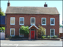 A house fit for a gentleman! Opposite the end of Castle Hill, turn to look at Somerville House. A gentleman's residence built in the mid-18th Century with a fine high gateway to allow carriages to enter. The porch, wall and railings at the front were added in the 19th Century. Cross the road (Castle Hill) and continue walking away from the Green. Look across Main Street at the old farm, Longlands Farm. The single-storey part nearest the Wheel was the old slaughterhouse and still has the hoist in it. The Wheel Inn next door has not changed externally for decades and is easily recognisable in a photo of 1918, but the land for the present car park and garden was bought in the 1930s from Longlands Farm. Opposite The Wheel is Longlands Lane, walk along here to the far end. The Longlands, now a private housing development, was built around 1659. It was the vicarage and part of a large estate which included a great deal of Findern. Rev. Benjamin Ward Spilsbury was the vicar here when the present church was built and, being a wealthy man, he paid for some of the stone to be transported to the village. There were Findern flowers growing here, as there were in many of the cottage and farm gardens. The shorter trail ends here and if you retrace your steps back to the Green and then to Lower Green you'll be back where you started. However, you can extend your walk in one of two ways: 1. Go back along Longlands Lane until you see the public footpath, between Numbers 31 and 29. Take the path over the fields until you get on to Heath Lane, and then walk towards the new bridge over the A50. Look back towards the houses on Longlands Lane and you should be able to see a ribbed pattern in the grass. This is evidence of strip farming as practised in medieval times when the lord of the manor allowed villagers to grow crops on strips of land. Now return to the village. 2. From the Longlands, walk up Hillside past the new playing field, to the second left turn – an unmade road leading to the Tower House and Mill Farm. The Tower House was originally a windmill built in 1715 and, from here, 22 churches can be seen on a fine day, including Lichfield Cathedral. By 1914 it had been converted into a dwelling. Edwina Currie lived here when she was MP for South Derbyshire in the 1980s. Retrace your steps to Hillside and this time cross over to the post box and walk straight down Porters Lane. The lane was used to carry (or porter) corn to the windmill and milk to the creamery and 'cheese factory' at Mill Farm. It was very narrow, there's one short part left but the remainder was widened when the estate was built. At the bottom you will rejoin Longlands Lane – turn towards The Wheel and walk to the Green. This walk was put together by Findern Historical Society. last updated: 06/04/2008 at 18:27 You are in: Derby > History > History Walks > Findern History Walk |
About the BBC | Help | Terms of Use | Privacy & Cookies Policy |