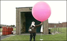
But none is of greater importance than the radiosonde. What’s a radiosonde? Well, you will find the answer at the Royal School of Artillery at Larkhill on Salisbury Plain. It is from here that the Met Office takes regular soundings of the skies above the West Country. The radiosonde itself consists of a small, lightweight polystyrene box. Inside there are temperature, pressure and humidity sensors plus a battery. This box of electronics is carried up through the atmosphere by a hydrogen-filled balloon. Before sending the radiosonde on its 20 mile through the atmosphere, the scientists on duty have to make sure the sensors are all functioning properly and the readings are true. When they are satisfied it is then time to attach the radiosonde to the weather balloon. The balloon is inflated by attaching it, via some rubber tubing, to a hydrogen cylinder. Hydrogen is highly flammable and the scientist must wear protective clothing in case of fire. When there is enough hydrogen to support the weight of the radiosonde, the final checks are made. If the coast is clear, with no aircraft in the vicinity, the balloon is released and the radiosonde begins its journey through the atmosphere. The progress of the radiosonde is tracked by computer. It sends back data on temperature and humidity at regular intervals and by tracking it on radar, we can also work out the wind speed and direction at any given height. By the time the balloon is at a height of about 100,000 feet it has grown in size, expanding against the cooler, thinner outside atmosphere. It will have increased from its original diameter of 1 metre, to almost 10 metres, before it finally bursts. To prevent the radiosonde from crashing to the ground at great speed, there is a parachute attached to ensure a gentle landing. In years gone by radiosondes were very much heavier and larger. Rewards were offered for their return. These days the circuitry is cheap to replace and the radiosondes are discarded after use. A graph of temperature (and humidity) against height is plotted on a tephigram - a graph from which we can work out all manner of things about the atmospheric conditions. The Artillery at Larkhill use the wind data to help improve the accuracy of their shells during firing exercises on Salisbury Plain. And changes in air temperature with height has an effect on the way sound carries so radiosonde data can help the army to keep the disturbance of the locals to a minimum. Tephigrams are vitally important to weather forecasters. They can be used to work out the height and thickness of clouds; whether they will develop from fine weather cumulus to towering rain bearing cumulonimbus; the speed of approach of weather systems. No matter how many weather stations we have in the region it is what goes on in the vertical that holds the key to predicting our changeable weather. So if you really what to know what the weather has in store, just wait for the balloon to go up. |