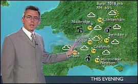
In the next hour or so I look at a host of data - computer output, forecast guidance, satellite, radar and observational data. When I am fully satisfied as to how I think the weather will unfold over the next few days I begin making up the weather charts that appear on the programme. The charts are produced on an Mac which is great for graphical work. I usually have a set of basic charts to cover tonight, tomorrow morning, tomorrow afternoon, tide times and the outlook. But other charts showing satellite images, weather radar or forecast winds can enhance the forecast, making the key points of the weather easier for the viewer to understand. When all the charts are prepared, I have combed my hair and straightened my tie, it is time to go into the studio. The weather forecast on Points West is usually about two minutes long. But I often find out the actual duration of the weather just as I am about to go on air. 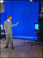 | | Where the camera sees blue, the weather map gets inserted |
I rely on the floor manager to give me the timings. He has signals for one minute and thirty seconds. As he begins his final countdown to zero, I have to wind up the forecast and hand back to the presenters. If I finish too early, the presenters will have to fill in. If I run over, then they may have to drop the headlines at the end of the problem and if I continue talking we may simply run out of time and the national news presenters will appear on screen at exactly 6:55 PM. All the weather forecasts and ‘live’ and there is no autocue. I simply cannot use a script because it is my job to fill any gaps in the programme and I have to be flexible. |