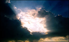
I wandered lonely as a cloud, That floats on high o’er vales and hills, When all at once I saw a crowd, A host of golden daffodils; William Wordsworth was captivated by them; so too were Turner and Constable who spent many years painting them. Clouds have always fascinated mankind but until fairly recently they were just ‘essences’ floating in the sky. This year marks the 200th anniversary of the first attempt to describe all the clouds we see in the sky And it is a system that we still use today. Luke Howard was an English chemist who also had a deep fascination with the weather. He recognised that there were four main types of cloud. Lumpy clouds with flat bases and cauliflower-shaped tops - he called cumulus from the Latin for ‘heaped’. Layered clouds - he called these stratus. Wispy, curly clouds - he called these cirrus. And, of course - being an Englishman - rain-bearing clouds - he called nimbus. These definitions appeared in his Essay on the Modification of Clouds published in 1802. Cloud occurs between the surface and 6,500 feet; medium cloud lies between 6,500 and about 16,500 feet. High cloud lies above 16,500 feet. That is four clouds and three layers. 4x3 = 12. That’s 12 main cloud types. We have expanded on Howard’s list and there are now 27 types of cloud plus 14 species and nine varieties. This allows us to describe the clouds very precisely - cumulus congestus, stratocumulus stratiformis; altostratus translucidus. Do all these obscure Latin names really matter? The answer is yes! Each cloud is an indicator of different things happening in our atmosphere. Whether the air is moist, its rising, descending, unstable or turbulent. Each one gives us a clue as to what the weather has in store. |