
All eyes now on Sunday: wild weather arriving?
UPDATE & CLOSING REMARKS, 08:20HRS, MONDAY 01 MARCH 2010:
I drove from Hertfordshire along the M25 and then westwards on the M4 during some of Sunday's worst conditions. The amount of standing water was especially treacherous on the motorways and unsurprisingly, the Environment Agency has issued a number of flood warnings in the wake of the heavy rain.
The Met Office's forecast of the most significant rain and winds affecting areas southeast of a line from around mid-Devon up to mid-Lincolnshire proved pretty accurate, as did the fairly swift clearance of inclement weather eastwards by around mid-afternoon.
 The storm caused a swathe of damage across parts of NW Europe, including here at Mainz, West Germany (Photo: AFP)
Sadly, the anticipated severe weather in France, Spain, Germany and other parts of NW Europe also became reality, costing the lives of at least 50 people. This BBC News report gives a graphic idea of just how badly many areas (especially in western France) were affected by Sunday's storm system. Indeed the French Prime Minister Francois Fillon has declared the event a national disaster, thereby freeing up funds to help businesses and communities recover.
You can read a number of eyewitness accounts of the storm here - described as "the worst I've ever encountered" by a woman in Persac, France.
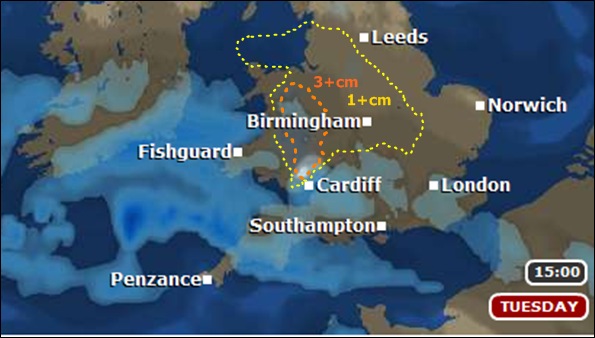
The quieter, drier spell of weather now across southern Britain will bring a good deal of blue sky and overnight frosts, before conditions become more 'mobile' once again from Wednesday onwards. A cold easterly windy will be very noticeable and whilst many areas will remain largely dry, some hill snow is likely at times from Wednesday onwards in the SW and elsewhere; perhaps a chance of more significant rain, sleet and snow in East Anglia by the weekend.
However, after a continuation of this cold, blocked anticyclonic pattern, there's a hint of temperatures starting to return to the norm within the latter part of this coming fortnight. Fingers-crossed for spring!
UPDATE, 17.30HRS, SATURDAY 27 FEB. 2010 (amended 22:10hrs):
The storm is has undergone explosive deepening NW of Portugal and is crossing the Bay of Biscay.
Hurricane Force 12 winds are expected in some sectors of the shipping lanes there tonight and we've recently seen gusts around 70mph near Santander.
Damaging winds are expected into parts of western and northern France later tonight and through the morning. The sting jet potential (mentioned in my last update) remains a real concern on the SW flank as the development continues. The Channel Islands - where tides will also be high - are likely to see winds gusting around 60-75mph for a while at least, early in the morning.
On this side of the English Channel, conditions will readily worsen tonight as the winds increase and rain starts to sweep across parts of the West Country and along the south coast, especially from midnight towards daybreak. So, very wet and very windy is an adequate summary for a number of counties, but many of you in the west will see a steady improvement even by midday.
Southeast of a line from around mid Devon up to mid Lincolnshire, some heavy rain will fall at times into the morning, widely giving 15-25mm accumulations and potentially 40-50mm locally in some areas of the extreme south between East Dorset and Kent. Certainly enough to cause local flooding problems and the Met Office has now issued FLASH warnings to highlight this threat. Coastal and estuarine flood issues from storm surge, combined with high spring tides, are also a concern for parts of the SE and East Anglia especially.
The strongest winds - whilst always on the south side of the low - will nonetheless make their presence felt here in England, especially through the morning as the system moves steadily eastwards. The current Met Office modelling suggests pretty wild conditions for a spell tomorrow in the likes of Hampshire, Sussex and Kent. Heavy rain will be across much of the SE around midday and I dare say the inclement conditions will surely prove troublesome for people travelling to Wembley for the Carling Cup final.
By the time it kicks-off at 3pm, we expect areas west of around Swindon to be seeing improving weather; indeed, sunny but still rather breezy conditions will be across much of the West Country potentially by around 1pm, with the heaviest of the morning's rain having cleared eastwards by then. But the wet weather - albeit perhaps not especially heavy by 3pm - is still likely to be falling above NW London when the football match starts.
Monday and Tuesday, incidentally, look a good deal drier and quieter! But the legacy from tonight / tomorrow's storm across parts of France and NW Iberia could well be very newsworthy indeed, for all the wrong reasons.
UPDATE, 23.30HRS, FRIDAY 26 FEB. 2010:
Sunday's storm is now forming west of the Canaries. Considering we're still watching an incipient phase - after which things will start to evolve quickly - and still many miles from our shores, the level of agreement between various forecast models on developments through the next 48 hours is quite noteworthy.
However, the last Met Office model takes the low slightly north of previous expectations by midnight Sat-Sun. The French Arpege model supports this idea, albeit with a somewhat less deep centre at the same timeframe.
So, no significant change - broadly speaking - from my last update, other than the likelihoood of some stronger winds into the SE quadrant of England during Sunday.
Crucially however, a real (worrying) potential identified by the Met Office scientists is a sting jet feature likely to threaten parts of northern France. If this becomes reality, it could take a swathe of 60-70mph gusts also across the Channnel Islands - briefly - early on Sunday morning. The impact on parts of France could prove far more newsworthy.
Around 20-40mm of rain is signalled from the latest Met Office modelling across the SE quadrant of England during Sunday, with snow into parts of the Midlands and perhaps southern-central England north of the M4, falling across areas mostly above 200m, at least for a while. The risk of coastal flooding is certainly a concern for some areas (see last update).
UPDATE, 10:30HRS, FRIDAY 26 FEB. 2010:
Generally good forecast continuity from the the Met Office's Global Model continues to offer a very similar story to my last update, with Sunday's storm expected to track across the Brest Peninsula and east-northeast through districts of northern France.
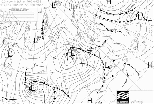
The latest synoptic chart from the Met Office for midday on Sunday - reproduced below - affords a very graphic indication of the tightly-packed isobars expected along the southern flank especially.
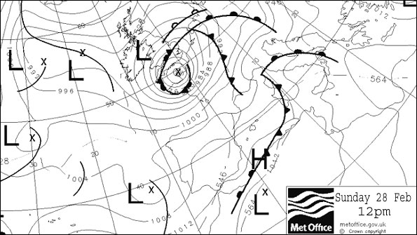 This will surely bring a spell of very severe weather across parts of N/NW France, where winds are forecast to gust up to 80+mph, doubtless causing a swathe of disruption and potential damage. Earlier, the storm is likely to have caused similar problems in NW Spain, before it crosses the Bay of Biscay tracking northeast.
For much of southern England and Wales, however, the likelihood of heavy rain remains our primary focus of attention, with the Met Office advising of accumulations around 25mm (1 inch) expected fairly widely and maybe double that in some districts. Local (inland) flooding is thus a matter of concern; perhaps also some problems developing in some coastal areas, with high tides on Sunday combining with the surge effects generated by strong winds.
Those winds - while certainly touching gale or even severe gale force, especially in the extreme south - are looking somewhat less menacing for the British Isles given the expected track of this low (albeit, as noted above, a far more dangerous outcome is expected across the other side of the Channel).
A continuing forecast complication is the chance of snow during Sunday as the storm departs further eastwards, increasingly drawing colder air off the North Sea and wrapping this around the system's north and northwest flanks.
The current Met Office view is for snow to fall across parts of the Midlands - including to lower levels - and across into Wales, but the southern extent of this potential remains unclear. Areas northwards of the M4 (e.g., perhaps including parts of Glos., Oxon and environs) look more at risk of at least some transient snow, but at lower levels it's unlikely to settle readily.
UPDATE, 20:00HRS, THURSDAY 25 FEB. 2010:
We're now entering a very interesting period of model-watching regarding developments for Sunday.
The Met Office's Global Model - showing pretty good continuity of late - has shifted the likely track of the storm just a tad to the southeast of previous runs. It's noteworthy how Arpege, the French forecast model, prefers an even more SE and slightly faster progression. And for that matter, so does GFS (the US global forecast model).
So which will prove correct?
The French solution has the 'eye' of this system, at a surface pressure of 976mB, making landfall around the Mouth of the Loire at midnight on Sunday morning. The Met Office version of events keeps a slightly slower and more northerly track than Arpege - with the low pressure centre still above northern Spain and entering the Bay of Biscay at midnight Sunday AM, before tracking up across the Brest Peninsula.
Either way, a swathe of strong winds - potentially up to 70kts and decidely perilous - is signalled to cross parts of N/NW France (with some of the most severe winds close to Paris) during Sunday, while heavy rain and windy weather affects much of southern UK.
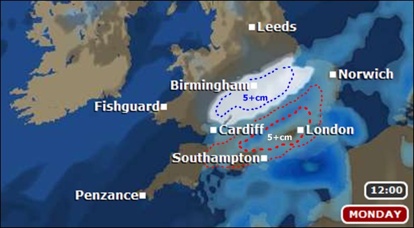
By late Sunday, with the low spinning away along northern districts of Benelux, a 'wrap-around' of colder air floods across the Midlands, Wales and parts of the West Country. The current lower-resolution Met Office modelling calls for between 2-6cm of snow from this 'tail-end-charlie' feature, including for the likes of upland Gloucestershire. However, that's very speculative and for sure, it's the heavy rain and associated flood potential that remains our main focus for attention.
If the current model trends continue, Sunday will give a spell of truly severe weather for parts of northern France and environs.
Meantime, it'll be a distinctly wet, windy but perhaps not 'severe' day of weather - in the strict sense - for much of southern Britain.
Quite understandably, continuing uncertainty regarding the precise track of this storm is the reason why the Met Office has held-off issuing advisories or warnings, for now, at least. But as ever, I'll update you on all the latest forecast detail tomorrow...
---------------------------------------------
(ORIGINAL ENTRY FOLLOWS)
This winter's fascinating and often dramatic weather changes complexion now for a while, with some distinctly wet and quite windy weather arriving later today (Thursday) and overnight.
Then - after generally drier, quieter conditions on Friday and Saturday - a much more troublesome-looking spell of weather is expected for Sunday.
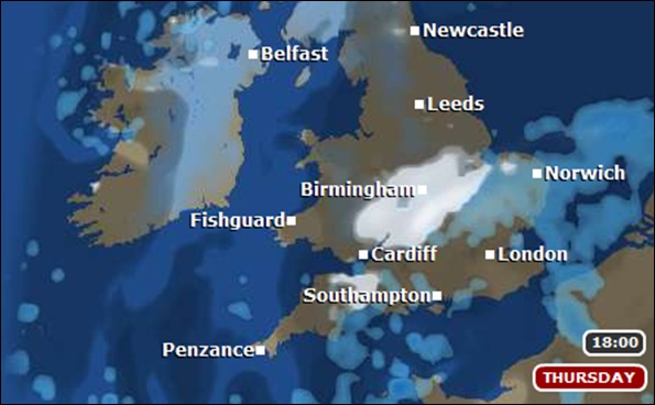
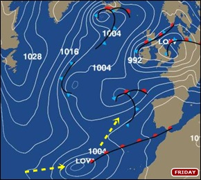 Down in southeastern reaches of the North Atlantic Ocean, way east of Florida, the potential for trouble arriving by Saturday night is already brewing. A wave-like disturbance in the atmosphere is gathering pace and will develop into a deep mid-latitude cyclone as it moves northeast.
The charts on the right show the expected track of this rapid cyclogenesis event, with the low centre moving towards NW Europe across warm oceanic waters and turning ever-more potent with each passing hour. If you're interested in the deeper science, the development is expected to be akin to the 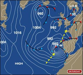 conceptual model known as Shapiro-Keyser. In short, it could get pretty nasty.
Current expectations take the feature very close to Madeira - where efforts are underway to recover from last week's deluge and the tragic consequences - before it buffets NW Iberia with strong winds and heavy rain.
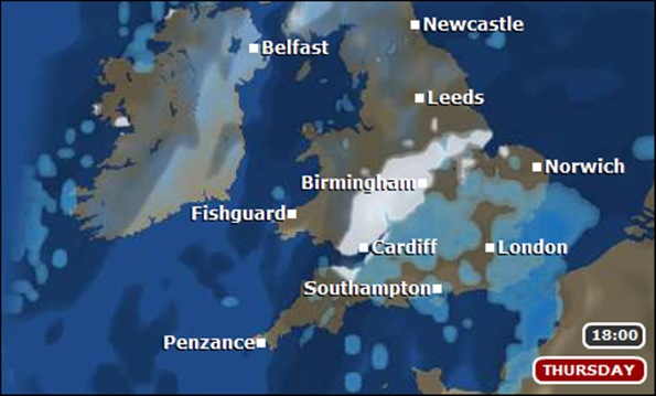
As the Sunday chart shows, the track continues up across the Bay of Biscay, but precision on the exact path it'll follow is yet to be determined. The Met Office's current expectation sees the centre of the low sweep through the English Channel, with strong winds especially on it's southern flank 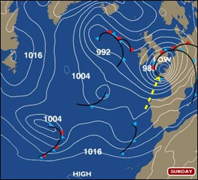 affecting coastal regions of France but also some coastal districts of southern England.
The impact across the British Isles will vary: for the West Country, our primary concern is a spell of potentially heavy, persistent rain falling onto already saturated ground. The spectre of local flooding is a worry in some areas of southern England. The winds will also be a feature - possibly gales or severe gales in exposed districts - albeit at least most trees are without leaves, hopefully mitigating the risk of widespread wind damage problems.
The north and northwest flank of the low will progressively entrain colder air, offering a temporary risk of snow over at least higher ground. The current Met Office model suggests such a risk through parts of the midlands, extending down into parts of Wales and the West Country - but there's a great deal of uncertainty about how extensive such snow could become, as the low tracks east. It's the heavy rain that gives us greater concern.
The Met Office is assessing the details and disparity on the rate of deepening, track and precipitation likely to arise from this storm; understandably, they're holding-off issuing formal advisories and warnings until the regional bias of risk is clearer. It's very much a story in motion - I'll keep you updated.


 I'm Ian Fergusson, a BBC Weather Presenter based in the West Country. From benign anticyclones to raging supercell storms, my blog discusses all manner of weather-related issues. I also provide updated race weekend forecasts tied to our BBC coverage of Formula One. You can follow me on