
UK and World weather report: unseasonable snowstorms & monster icebergs
Distance travelled ~ 799'068'800 km
October was a mild month - with some exceptionally high minimum temperatures for the time of year - ending with another mild day on Monday. Several locations did not dip below 15 °C all day and a top temperature of 19.3 °C was recorded at Kinloss. As the week continued into November, the mild temperatures carried on, with a high of 18 °C at Heathrow and St James' Park on Thursday.
Rain dominated the week, with occasional rain on Monday turning into a band of heavy rain on Tuesday and widespread heavy and sometimes thundery outbreaks on Wednesday and Thursday. There were also some possible funnel cloud sightings, one of which may have touched down in Astwood Bank, just south of Redditch.
Friday bought more wet weather, with intense rain in parts. Alice Holt Lodge near Odiham, Hampshire, recorded well over 50mm of rain between midnight and 7am, and there were numerous reports of localised flooding in the Home Counties.
The weekend was slightly cooler, with a chilly start to both days and frost in many northern areas on Sunday morning.
Elsewhere in the world, flooding continues in Thailand. A third of the country has now been affected by flooding after three months of heavy rain. Over 500 people are said to have died and there are fears that the flooding could worsen in the capital Bangkok.

Image Credit Remko Tanis
Deadly flash floods also hit the Liguria region of Italy on Friday after heavy rain. Two rivers in Genoa reportedly broke their banks as floodwaters poured through the port city for the second time in eight days, killing six people. Much of northern Italy was affected by the heavy rain during the day, including Venice, which also suffered flooding.
Close to two million homes are still without power after an unseasonable snowstorm hit the US east coast last weekend. The storm, which brought up to 76 cm of snow in parts, has been blamed for as many as 19 deaths. At the storm's height, three million homes were without power, while states of emergency were declared in New Jersey, Connecticut, Massachusetts and parts of New York.
Scientists are monitoring the birth of a monster iceberg in west Antarctica. The iceberg is expected to break away towards the end of the year or early in 2012. Currently, the crack is 30 kilometres wide and 60 metres deep and growing every day. Researchers from NASA expect the eventual iceberg to cover 880 square kilometres - an area the size of Berlin.
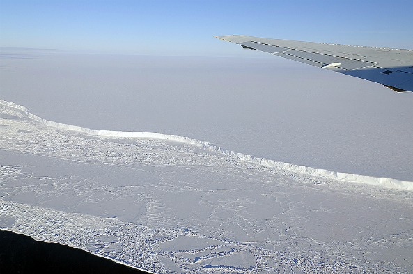
Image Credit NASA
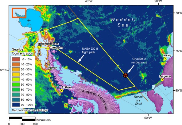
Image credit NASA
The week ahead
In the UK:
• Monday and Tuesday will be dull and cloudy and occasionally damp across the country, but temperatures will be mild. Wednesday and Thursday see more persistent rain moving into western areas, while the east may become a little brighter. Staying mild, especially overnight, with light southerly winds. As we head into the weekend mild southerly winds should bring broken cloud to many parts.
Elsewhere in the world:
• There is the potential for a tropical cyclone to form in the Arabian Sea. A depression was centred about 700km east-southeast of Salalah on Monday and the system is forecast to intensify further into a deep depression and move towards the Oman coast over the next three days.
• A tropical depression formed close to Hainan Island in the South China Sea on Monday. China mainland provinces of Guangdong and Fujian, the island province of Hainan, as well as Taiwan, will be subject to the periods of heavy rain through much of the week.
• Unsettled periods of weather look set to affect the western Mediterranean, parts of Canada and northern Russia, although nothing particularly exceptional is currently signalled.
• Over the USA, an outbreak of potentially damaging thunderstorms and tornadoes looms for the southern Plains on Monday. The thunderstorms may ease for a time overnight and into Tuesday, but is forecast to increase once again on Tuesday afternoon with the threat zone stretching from central Missouri to East Texas and Louisiana.
• Unseasonably cold conditions are forecast across the Caucasus', spreading to much of the Middle East through the week.
 Kate Humble:
 Helen Czerski:
 Stephen Marsh:
 Aira Idris:

Comments Post your comment