
Day 325: This week's extreme weather watch
Distance travelled ~ 835'409'600 km
It was another mild week across the UK, with maximum temperature reaching the mid teens every day and a high of 16.2 °C recorded at Gravesend on Thursday.
Provisional figures show that November so far has been very mild across the UK. The UK average temperature for 1-15 November was 9.4 °C, 3.5 °C higher than the long term average.
We would normally expect the first half of November to be warmer than the second as we transition towards winter (which, meteorologically speaking, starts in December). However, even bearing this in mind, the temperatures seen in the first half of this month have been much warmer than normal.
Some areas did see lower temperatures overnight, leading to air and ground frost in parts, particularly in the north west. A minimum temperature of -3.6 C was recorded at Drumnadrochit, on Loch Ness, on Wednesday.
The weekend saw extensive fog form in eastern areas. On Saturday this was very slow to clear parts of Yorkshire, Lincolnshire, Cambridgeshire and the East Midlands. While on Sunday areas from the Vale of York through the East Midlands to southern England saw dense patches of fog with visibility of around 50 metres in places. Fog thinned or lifted into low cloud in many places, however for parts of the Vale of York, Lincolnshire, East Anglia and the London area, it stuck around all day causing some flights to be cancelled at Heathrow Airport.
It's been a relatively quiet week of weather for the rest of the world. In Bolivia, a rare tornado damaged parts of the city of Cochabamba on Wednesday.
Thunderstorms moving through the region produced the tornado which reportedly damaged dozens of buildings.
There's been heavy rain in Taiwan, with some parts of the country seeing over 400mm of rain this week.
Heavy snowfalls affected parts of the Upper Midwest in the USA where a foot of snow fell on parts of South Dakota. A thick fog in Germany may have been a factor in a 52 vehicle pile up on the Autobahn near Muenster. Three people were killed in the crash and another 35 were injured.
The week ahead
The UK:
• A gradual transition to temperatures closer to average by the end of the week, when windy conditions will dominate with heavy rain at times in the northwest of the UK.
Across Europe:
• Temperatures in Turkey and the eastern Mediterranean continue to be cold for the time of year, with hill snow expected at times.
Across the Americas:
Tropical storm Kenneth is currently 500 Miles SSW of Manzanillo, Mexico, but is expected to move in a westward direction, away from land. This is the latest in the season that a tropical storm has formed in the eastern north Pacific basin since Hurricane Winnie formed on 4 December 1983.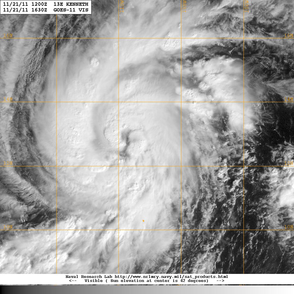
• The unusually cold conditions are set to continue across Alaska and NW Canada over the next few days, spreading into northern areas of the USA such as North Dakota and Minnesota. Temperatures are 10 Celsius colder than average, remaining well below zero in many places throughout the day. By Tuesday temperatures should rise to nearer normal as low pressure pushes in from the south.
Across Australasia:
• New Zealand's South Island may see 250 mm of rain during the early part of the week in parts of Westland and Buller.
 Kate Humble:
 Helen Czerski:
 Stephen Marsh:
 Aira Idris:

Comments Post your comment