
UK and World weather report: Jova strong cat 3 hurricane moving east
Distance travelled ~ 727'298'400 km
After a period of record-breaking settled weather last week, most of the UK saw a return to normal autumn conditions by Tuesday. A band of cloud spread across most of England and Wales, and showers continued in Scotland and Northern Ireland.
Wednesday and Thursday saw strong northwesterly winds for many, reaching gale force on higher ground in the north. On Thursday a yellow warning was in place for gusts of up to 65mph for parts of the North West and Northern Ireland, with winds in excess of 40mph recorded widely. The strongest gust at low levels was 66mph at Machrihanish in Scotland.
Temperatures fell compared to last week but were still above average in many areas for October, with a high of 22.1 °C in Bridlington on Wednesday. Although on Friday it was a chilly start for many, with temperatures falling into single figures and a low of -1.5 °C at Cairngorm in Scotland.
Elsewhere in the world, Winnipeg in America has also been experiencing warm autumn weather, with temperatures 18 °C above what is seasonally normal. It reached 31 C on Thursday, the hottest October day in Winnipeg since records began.
Several days of heavy rain in central Algeria have caused the deaths of eight people and widespread damage to roads and bridges. There has also been heavy rain in Haikou, China, where 17,000 people were evacuated after days of torrential rain raised the level of the Nandu river higher than the warning line.
One man has been killed and 12 injured in a massive pile-up after a dust-storm rolled across an interstate in Arizona. The collision on Interstate 10 near Picacho - midway between Phoenix and Tucson - involved 16 vehicles.
In Australia, almost 11,000 homes are without power after severe thunderstorms battered Queensland. However, damage from flooding has been minimal, with only 22 calls made to the State Emergency Service for leaking roofs.
Severe weather watch: The week ahead
Across Europe:
• Unsettled conditions are expected to continue to affect some northern parts of Europe through the start of the week.
• Warm and quiet conditions are expected to return to many areas from midweek as high pressure builds once again across Europe.
• The former Hurricane Philippe is set to head well north across the Atlantic, bringing gales and heavy rain to Iceland and East Greenland. In so doing, Philippe will give the UK a wide berth and will have no direct weather impact here.
Over the Americas:
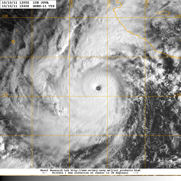
• In the eastern Pacific Hurricane Jova and Tropical Storm Irwin are both moving towards Mexico. Jova is a Saffir-Simpson Category 3 Hurricane moving East (winds ~120 mph) and is expected to make landfall somewhere near Manzanillo on Tuesday.
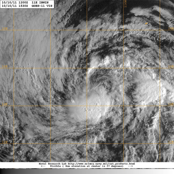
Irwin is forecast to approach the west coast of Mexico on Thursday or Friday. Maximum sustained winds 35knots; 40mph moving east at 7mph.
• There are unsettled conditions to the east of the Philippines at the moment and this may develop into a typhoon this week.
 Kate Humble:
 Helen Czerski:
 Stephen Marsh:
 Aira Idris:

Comment number 1.
At 16:40 21st Nov 2011, noelwhitecliffe wrote:This comment was removed because the moderators found it broke the house rules. Explain.
Complain about this comment (Comment number 1)