The Mailbox complex is well served by local public transport services. Location map of the Mailbox | | | Click here to see a map showing the location of bus stops, train and metro stations close to the Mailbox. |
Below is a summary of train, bus and metro services to and from the Mailbox. The nearest railway station to the Mailbox is Birmingham New Street.
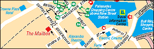
| New Street to The Mailbox (on foot) |
Exit New Street Station from the Victoria Square entrance/exit. Turn left at exit and walk down Navigation Street, crossing over the pedestrian crossing at the junction with Hill Street.
Continue down Navigation Street and walk under the Suffolk Street Queensway road bridge, following the painted lines on the path which will direct you to the Mailbox. Mailbox Square is directly in front of you once you walk under the road bridge.  This walk should take approximately 5 minutes. This walk should take approximately 5 minutes.
| Snow Hill Station to The Mailbox (on foot) |
Snow Hill Station to The Mailbox, on foot
Exit Snow Hill from the main entrance and turn right on to Colmore Row. Walk down Colmore Row to Victoria Square. Cross over Victoria Square and turn left down Hill Street, past Swallow Street,
until you reach Navigation Street. Turn right into Navigation Street, continue down Navigation Street and walk under the Suffolk Street Queensway road bridge. Mailbox Square is directly in front of you once you walk under the road bridge.
This walk should take approximately 10 to 15 minutes.
Moor Street Station to the Mailbox (on foot) |
Exit Moor Street Station and cross over Moor Street Queensway. Walk up Carrs Lane and turn left on to High Street. Walk down the High Street and turn right into New Street. Walk up New Street and then turn left onto Stephenson Street.
Turn left into Navigation Street, walking down Navigation Street, crossing over the pedestrian crossing at the junction with Hill Street.
Continue down Navigation Street and walk under the Suffolk Street Queensway road bridge, following the painted lines on the path which will direct you to the Mailbox. Mailbox Square is directly in front of you once you walk under the road bridge. This walk should take approximately 10 to 15 minutes.
Centrebus 77 An alternative to walking from Moor Street or Snow Hill train stations is to catch the Centrebus 77. Centrebus 77 operates every 12 minutes between 7.00am and 7.00pm on Mondays to Saturdays and runs in a clockwise direction around the city centre. The Metro tram operates between Wolverhampton St Georges and Birmingham Snow Hill. It runs every 8 minutes in the daytime and every 12 minutes after 7pm, stopping at 23 stations including West Bromwich, Wednesbury and Bilston. For walking directions from Snow Hill to the Mailbox, see above. Birmingham city centre is accessible by bus from most locations in the West Midlands. Please call the Centro Hotline on 0121 200 2700 to confirm your bus stop location, journey times and fares before travelling.
|