| You are in: Science/Nature | |||||||||||||||||||||||||||||||||||||||||||||||||||||||||||||||||||||||||||||||||||||||||||||||||||||||||||||||||||||||||||||||||||||||||||||||||||
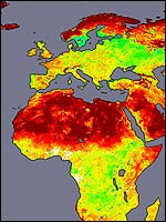
| Thursday, 11 July, 2002, 13:57 GMT 14:57 UK Earthshine map helps predict weather The variable terrain of North Africa as seen from Terra The "Earthshine" data should give scientists a better understanding of how the atmosphere works. The Moderate Resolution Imaging Spectroradiometer (Modis) instrument on Terra routinely measures this so-called albedo. Researchers say the new data from Terra are just what they would expect as the satellite passes over the wide range of geological features found across the planet's surface. "Zooming in on Africa's Sahara Desert and the Arabian Peninsula, for instance, Modis observed considerable variability in reflectance across the region - from the darkest volcanic terrains to the brightest sand sheets," said Elena Tsvetsinskaya of Boston University. Vital role Albedo information is important because most weather forecasting models treat this region as uniform. But, in reality, reflectance variations produce heating differences that result in atmospheric motions that influence clouds and rain. By combining Modis data with geologic information, Tsvetsinskaya and colleagues have provided weather and climate analysts with a new map of albedo across Northern Africa and the Arabian Peninsula so that they can fine-tune their forecasts.
As the snow melts in spring, the forests are exposed to the sunlight. The vegetated surface is much darker and absorbs light, which warms the surface. Scientists recently discovered that once the snow melts in the Earth's northern forests, the surface releases a significant amount of heat into the overlying atmosphere that influences global weather systems. The Modis albedo measurements allow scientists to monitor how the Earth's reflectivity changes on a global scale. "This will help us determine how the Earth's climate is changing, both globally and locally," said Crystal Schaaf of Boston University. Launched on 18 December, 1999, Terra is the flagship of Nasa's Earth Observing System series of satellites. Its data may allow scientists to better understand and predict how various surface features absorb and reflect solar radiation, which influence both short-term weather patterns and longer-term climate trends. | See also: 20 Apr 00 | Science/Nature 30 May 01 | Science/Nature 27 Jul 01 | Science/Nature Top Science/Nature stories now: Links to more Science/Nature stories are at the foot of the page. | |||||||||||||||||||||||||||||||||||||||||||||||||||||||||||||||||||||||||||||||||||||||||||||||||||||||||||||||||||||||||||||||||||||||||||||||||
Links to more Science/Nature stories |
 | Back to top | |||
| ---------------------------------------------------------------------------------- To BBC Sport>> | To BBC Weather>> | To BBC World Service>> ---------------------------------------------------------------------------------- © MMIII | News Sources | Privacy |