| You are in: UK: N Ireland | ||||||||||||||||||||||||||||||||||||||||||||||||||||||||||||||||||||||||||||||||||||||||||||||||||||||||||||||||||||||||||||||||||||||||||||||||||
| Wednesday, 23 October, 2002, 14:03 GMT 15:03 UK Meg in the middle 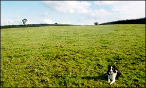 Meg lives at the centre of Northern Ireland
The one-year-old border collie was an unlikely ally as BBC News Online embarked on a search for Northern Ireland's geographic centre. The co-ordinates, calculated by the Ordnance Survey of Northern Ireland, took the search to a spot known as Annaghone, between Cookstown and Stewartstown. When it became necessary to trudge across paddocks, Meg mysteriously appeared from a nearby house and joined the hunt.
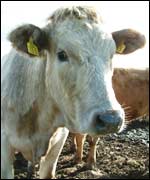
The true centre of Northern Ireland ended up being located in a verdant paddock occupied by 15 cows. Local farmer and Meg's owner, John Millar, said he was not surprised to discover the centre was near his home. "I knew it wouldn't be far away because we thought it was somewhere between here and Lough Neagh. Hard work "I thought it may have been a little closer to Stewartstown perhaps." The dairy farmer said he enjoyed life on the land, although sometimes it was hard work. "I like it when the weather is good... but it can be really tough so when the weather is bad," he said.
The true centre lies in a paddock adjacent to Mr Millar's property, on a cattle farm owned John Faulkner. Mr Faulkner does not live there, preferring to stay at his house in Cookstown, but he visits the paddock several times a week. He was surprised to learn his paddock was a special site. Like many people, he believed the centre of Northern Ireland was further west in the town of Pomeroy. "People say something and you just believe it... I never thought it was anywhere but Pomeroy." 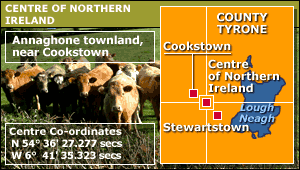 So, does Mr Faulkner intend to build a monument or tourist attraction? "I don't think so, I'll just leave it to the cows," he decided. And what is life like at the centre of Northern Ireland. "It's good farmland, but it can be quite windy," Mr Faulkner said. Cardboard cut-out The Ordnance Survey of Northern Ireland calculated the centre of the country using a "centre of gravity" method. To put it simply, this determines the point at which a cardboard cut-out of the country would balance on the tip of a pencil. BBC News Online then located the point using a global positioning system (GPS), which finds co-ordinates with help from satellite signals. There are numerous methods to find the centre of countries, but the gravitational method is preferred by many mapping agencies, including the Ordnance Survey of Great Britain. Over this week, BBC News Online is revealing what lies at the centre of each of the home nations. The reports include:
|
Internet links: The BBC is not responsible for the content of external internet sites Top N Ireland stories now: Links to more N Ireland stories are at the foot of the page. | ||||||||||||||||||||||||||||||||||||||||||||||||||||||||||||||||||||||||||||||||||||||||||||||||||||||||||||||||||||||||||||||||||||||||||||||||
Links to more N Ireland stories |
 | Back to top | |||
| ---------------------------------------------------------------------------------- To BBC Sport>> | To BBC Weather>> | To BBC World Service>> ---------------------------------------------------------------------------------- © MMIII | News Sources | Privacy |